Nachrichten und Veranstaltungen
Webinar "Kartenportal vs. Google Maps"
März 19, 2024 11:00 bis März 19, 2024 12:00
Die ETH-Bibliothek bietet morgen Dienstag 19. März ein Webinar (online via Zoom) zu Kartenportal.CH an (Dauer: 11 - 12 Uhr). Inhalte: Was ist Kartenportal.CH? Unterschiede zu Google Maps, Open Street Map usw. Suchstrategien Weitere Fachportale für Karten und Geodaten Übungen Weitere Informationen und die Anmeldung... Weiterlesen
Prachtsatlanten – ein Citizen Science-Projekt
Februar 15, 2024
2023 führte die Kartensammlung der Zentralbibliothek Zürich (ZB) erfolgreich das Citizen Science-Projekt «Prachtsatlanten» durch. Für dieses Projekt wurden über 2900 alte Landkarten aus den ältesten und schönsten Prachtsatlanten des 15.-17. Jahrhunderts ausgewählt und digitalisiert. Citizen Scientists wurden daraufhin eingeladen, die darin enthaltenen Karten zu georeferenzieren.... Weiterlesen
Kartensammlungen finden
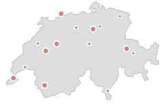
Die Sammlungprofile aller Schweizer Kartensammlungen auf einen Blick: Das Verzeichnis mit Standortkarte und Suchfunktion führt Sie zu interessanten Kartenbeständen in Ihrer Nähe und gibt Auskunft über Bestände, Dienstleistungen und Publikationen der Bibliotheken und Archive in der Schweiz.
